Software Development, Three Dimensional Laser Scanning, Residential And Commercial Development Surveys, Transportation And Infrastructure, Mining & Tunneling, Geomatics Engineering Surveys, Professional Land Surveyors & Geomatics Engineers, COR Certified, First Nations Development Surveys, Geodetic Surveying, Construction Surveying, Engineering Surveying, Land Development, Oil And Gas, Cadastral Surveying, Housing Development, Computation And CAD Mapping
Professional Land Surveyors and Geomatics Engineers serving Northern Canada since 1960, with a full range of services including Cadastral, Engineering and Geodetic surveys, Mapping and GIS services.more...See more text
Software Development, Three Dimensional Laser Scanning, Residential And Commercial Development Surveys, Transportation And Infrastructure, Mining & Tunneling, Geomatics Engineering Surveys, Professional Land Surveyors & Geomatics Engineers, COR Certified, First Nations Development Surveys, Geodetic Surveying, Construction Surveying, Engineering Surveying, Land Development, Oil And Gas, Cadastral Surveying, Housing Development, Computation And CAD Mapping
Underhill Geomatics Ltd. (UGL) was established in Vancouver in 1913 and has operated continuously since then, providing comprehensive geomatics expertise to industry, government an...more...See more text
Access Road And Design, Construction Surveys And Layout, Development Permit Surveys, LIDAR, Geographical Information System (GIS) And Photogrammetry, Land Information System (LIS), BC Land Surveyors Certificate Of Location (residential/commercial/industrial), Surveying Easements, Right Of Ways, Leases And Other Charges Against Parcels, Natural Boundary Surveys, Facility Construction And Upgrades, Road Construction Surveys, Resource Development Mapping, New Home Construction Layout, Volume And Area Calculations, Boundary Surveys, Utility And Corridor Surveys (Rights Of Way), Site, Topographical & As-built Surveys, High Definition 3D Scanning, Subdivision Surveys (rural & Urban), Strata Surveys
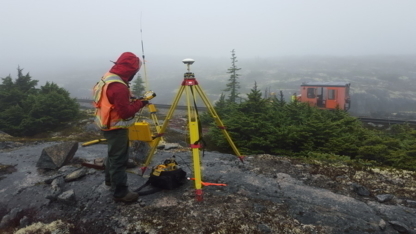
Allnorth Land Surveyors is a Registered Land Surveying firm in the Province of British Columbia, serving heavy industrial, commercial, and public and private sector clients since 1...more...See more text
Excellent company, I wasnt sure if I wanted to survey my house before building, so glad that I did. They did a great job and Ive used them several times since. I would definetly recommend this company.Read more
Surveying, Product Management And Inspections, Transportation And Infrastructure, Quality Control Material Testing, Pile Driving Analysis, Mining Surveys, Land Development Surveys, Building Layout Surveys, Condominium Surveys, Computation And CADD Mapping
CAP is a knowledge?based company that unites senior level professionals and young aspiring professionals in a mentorship style environment. Our goal is to combine the wisdom and ex...more...See more text
Highland Geomatics, based in Strathpeffer, near Inverness, in the heart of the Scottish Highlands, provides mapping, plans, surveying and geographical information systems (GIS) con...more...See more text
Engineering Surveys, Pipeline Integrity, Construction Services, Well Sites, Power & Utility
Can-Am is an innovative company, established in 1973 providing high quality, cost effective geomatics services to a variety of clients. Our clients include oil & gas, pipeline, mun...more...See more text
Legal Surveys, Line Locates & Buried Structures, Mineral Claims, Pipeline Surveys, As-built Surveys, Wellsite Surveys, Custom Mapping Services, Industry Road Design, Control Network Surveys, Subdivisions, Building Layouts, Topographical Surveys, CADD Drafting Services, Volume Surveys, Canada Lands Surveys, Wellsite Pad Design, Construction Surveys, Aerial Mapping
Vector Geomatics Land Survey has a physical office in Fort Nelson BC with a resident land surveyor to assist you with Construction Surveys, Legal Surveys, Gas Industry Surveys, as ...more...See more text